Lens is more

I mentioned at the end of last week’s post that I’d like to try time lapse photography. This week, I’ve been doing a bit more research. We’ve got a couple of Canon DSLRs at work so I had a look on the Canon website for more information on time lapse photography. There are four tutorial videos by award-wining photographer and “Canon Explorer of Light” Vincent Laforet.

From the website:

“Vincent Laforet introduces basic time lapse concepts including what to look for when searching for the ideal time lapse subjects, how to ensure smooth movement during playback, and other useful tips to get started.”

I found the videos really informative and now think I could probably have a go at shooting a time lapse movie. Here’s a photo that might give a bit of a clue as to what I’d like to film…

Crosby beach - photo by Bev Goodwin

Photo by Bev Goodwin

The only slight issue is that I don’t think we have any of the lenses that Vincent recommends in his tutorial videos. I had a quick look online and they all seem to cost about £1500! I’ll have to see if I can do it with a cheaper wide-angle lens instead…

In the edit

This week, a few of us attended an introductory course on filming and editing at Futureworks in Manchester. We spent four days learning how to plan, shoot and edit a short film.

Day one was spent learning how our video camera works, how to shoot video using DSLR cameras and the basic principles of lighting. On the morning of day two we learned how to plan and storyboard a shoot; in the afternoon we went to Manchester Art Gallery (on location, as I believe it’s called!) to film a short piece about a couple of the current exhibitions there.

Filming in Manchester Art Gallery

Day three was spent in the editing suite where we learned how to import our clips, rearrange them, edit them and create a timeline. Day four was all about adding the finishing touches, audio, effects, titles, etc.

Editing at Futureworks
Having just completed the course, I feel we can now produce a short film by ourselves on our project for JISC. We’re all bursting with ideas about exciting content. I’m hoping we can get an intervalometer so we can do some time-lapse filming…

Mixed huts

Most of the earliest sea level data records come from commercial or military ports. Having a record of the tide was important for ship navigation. Sea level records were also important tools in the establishment of a national datum, or zero level, to which heights on maps would be referred.

Some of the earliest tide gauges (which have given us some of longest sea level records in the world) were housed in specially designed huts. Because of their age, a lot of these buildings are of unique and interesting design. Below are a few examples.

Kronstadt tide gauge hut


From Wikipedia:

“The Kronstadt sea-gauge with the tide gauge pavilion is a zero-level of the Baltic system depths and heights. All depths and altitudes (even the heights of the flight spacecraft) in Russia and some other countries (former Russian Empire) are measured from the level of Kronstadt sea gauge. Yuri Gagarin, the first spaceman in the World, ironically said in 1967 that this is it the Hub of the Universe.”

The sea level has been measured at Kronstadt (although not always at the same location) since 1777, making it one of longest sea level records in the world.

Some more tide gauge buildings:

Ystad tide gauge building

Ystad, Sweden. Sea level has been recorded here since 1887. Photo by Anders Lagerås.

Leixoes tide gauge building

Leixões tide gauge, Portugal. Built 1890.

Port Arthur tide gauge building

Port Arthur, Tasmania, Australia. First recordings were made in 1841.

Cape Town tide gauge building

Waterfront clock tower – Cape Town, South Africa, built in 1882. Photo by Michael Coghlan.

Vernadsky tide gauge building

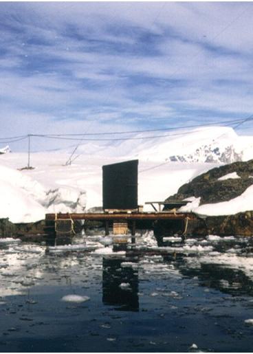
Vernadsky hut, built 1958. Longest tide gauge record in Antarctica.

Skeppsholmen tide gauge building

Stockholm-Skeppsholmen, installed in 1889. Sea level has been recorded in Stockholm since 1774. Photo by Thomas Hammarklint.

Newlyn tide gauge building

Newlyn’s tide gauge is located here. Operational since 1915.

The Tidal Observatory was established to determine the mean sea level used as the starting point for levelling in the UK. A brass bolt on the site is the benchmark for the whole of the United Kingdom. All Ordnance Survey map heights are referenced to this point.

The height of the benchmark was established over a six-year period from 1915 to 1921. Visual observations of water level on a tide staff were made every 15 minutes, 24 hours a day, 365 days a year. From the data collected over this period, mean sea level was caculated and this vertical level marked with the bolt.

Talking Shop

The National Oceanography Centre, Liverpool, holds a weekly seminar every Wednesday during university term time. Though the lab specialises in shelf sea and sea level science, the seminar series is broad in scope, covering all aspects of oceanography, climate science and geophysical fluid dynamics. Seminars are attended by Ph.D. students, researchers and senior scientists from NOC and the University of Liverpool.

The Joseph Proudman Building, home of the National Oceanography Centre, Liverpool. Image credit: Rept0n1x (CC BY-SA 3.0)

The Joseph Proudman Building, home of the National Oceanography Centre, Liverpool. Image credit: Rept0n1x (CC BY-SA 3.0)

Next week, I will be giving the seminar, the title of which is “Marine Data Management: Past, Present and Future”.

Read the abstract: http://noc.ac.uk/seminars/liverpool/marine-data-management-past-present-future

The first section of the talk will focus on data archaeology and I hope to explain the importance of recovering, quality controlling and distributing historic data. I’ll be discussing the JISC Sea level project as an example. It will also help raise awareness of this project within the lab and at other organisations and let people know there will be more data available soon.